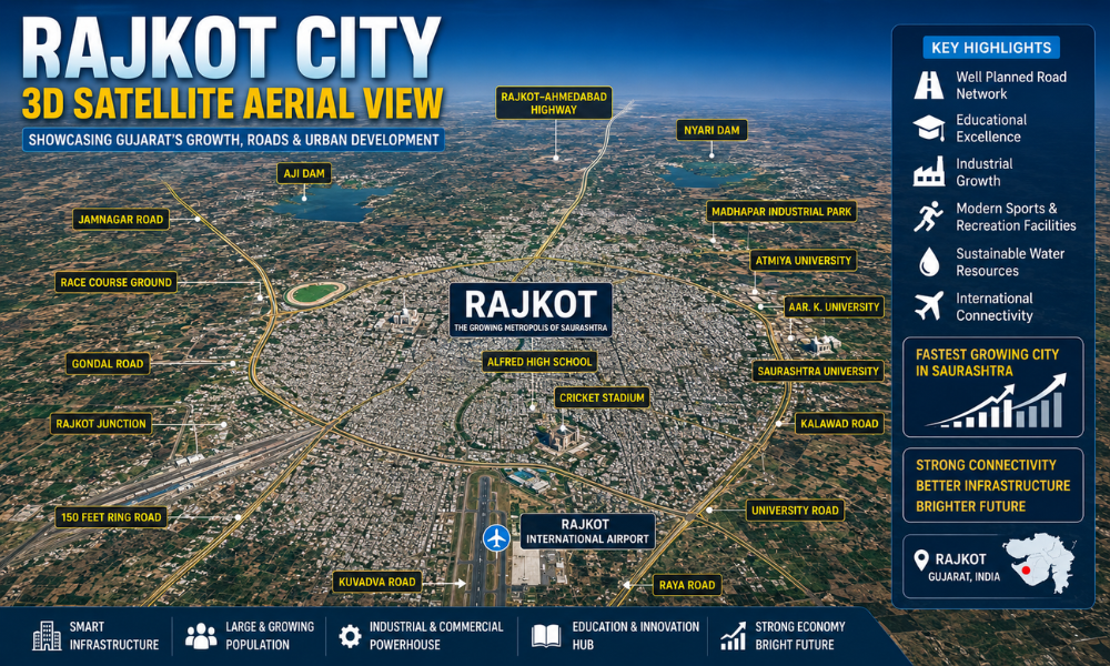
Rajkot, one of Gujarat’s fastest-growing cities, is beautifully captured in this stunning 3D satellite aerial view. The image provides a comprehensive perspective of the city’s urban expansion, transportation infrastructure, educational institutions, industrial growth, and major landmarks. Located in the heart of the Saurashtra region, Rajkot has emerged as a major economic, educational, and cultural center that continues to attract businesses, investors, students, and tourists from across India.
The aerial view clearly illustrates how Rajkot has transformed from a historic princely state into a modern metropolitan city with world-class infrastructure. Well-planned roads, expanding residential zones, industrial corridors, educational campuses, and public facilities reflect the city’s commitment to sustainable urban development and economic progress.
Historical Importance of Rajkot
Rajkot derives its name from the former Rajkot State and has a rich history dating back several centuries. The city holds a special place in Indian history because of its association with Mahatma Gandhi, who spent part of his childhood here. The famous Kaba Gandhi No Delo, the ancestral residence of Gandhi’s family, remains one of the city’s most visited historical attractions.
Over the years, Rajkot has evolved from a royal administrative center into one of Gujarat’s most important urban hubs. Today, it serves as a key commercial and industrial gateway for the entire Saurashtra region.
Strategic Location in Gujarat
Situated in western Gujarat, Rajkot enjoys a strategic geographical position that connects major cities and industrial zones. The city acts as a central node for trade, manufacturing, engineering, agriculture, and education. Its connectivity through highways, railways, and air transport has significantly contributed to its rapid development.
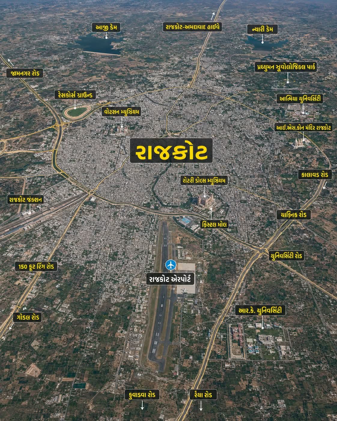
The aerial map highlights Rajkot’s extensive road network and showcases how the city has expanded in all directions while maintaining strong transportation links with other parts of Gujarat.
Major Roads and Transportation Corridors
One of the most striking features visible in the satellite image is Rajkot’s modern road infrastructure. Several major roads and highways serve as the backbone of urban mobility and economic activity.
Rajkot-Ahmedabad Highway
The Rajkot-Ahmedabad Highway is one of Gujarat’s most important transportation corridors. It connects Rajkot with Ahmedabad, the state’s largest city, facilitating business, logistics, tourism, and daily travel. The highway plays a crucial role in supporting industrial growth and trade movement.
Jamnagar Road
Jamnagar Road provides direct connectivity to the industrial city of Jamnagar and major coastal regions. This route is important for transportation, commerce, and access to petroleum and manufacturing industries.
Kalawad Road
Kalawad Road is among Rajkot’s most developed urban corridors. The area is known for premium residential projects, commercial complexes, educational institutions, shopping centers, and hospitality establishments. Its rapid development reflects the city’s modern urban planning.
University Road
University Road serves as an educational and commercial hub. The presence of educational institutions, coaching centers, residential developments, and business establishments makes it one of Rajkot’s most vibrant areas.
Gondal Road
Gondal Road is a significant industrial and commercial route connecting Rajkot with Gondal and surrounding regions. Numerous manufacturing units, engineering industries, and logistics businesses operate along this corridor.
Kuvadva Road
Kuvadva Road has witnessed substantial industrial and residential growth over the past decade. The road serves as an important connection between Rajkot and nearby industrial clusters.
Ring Road Network
The city’s famous 150 Feet Ring Road plays a vital role in traffic management and urban connectivity. It allows smooth movement across different parts of Rajkot while reducing congestion in central areas. The ring road has become one of the most important landmarks in the city’s transportation infrastructure.
Rajkot International Airport
One of the most prominent features visible in the aerial view is Rajkot International Airport. This modern aviation facility has significantly enhanced the city’s connectivity with major domestic and international destinations.
The airport is expected to accelerate tourism, trade, investment, and business opportunities across the Saurashtra region. It also strengthens Rajkot’s position as a major economic center in western India.
Educational Excellence
Rajkot has established itself as an important educational destination in Gujarat. Several renowned universities and institutions can be identified in the satellite image.
Atmiya University
Atmiya University is one of the city’s leading educational institutions, offering programs in engineering, management, science, commerce, and technology. Its modern campus contributes significantly to Rajkot’s educational ecosystem.
R.K. University
R.K. University is another prestigious institution known for higher education and professional courses. The university attracts students from various states and supports research, innovation, and skill development.
The presence of these universities has transformed Rajkot into a prominent academic hub for the Saurashtra region.
Sports and Recreation Infrastructure
The aerial view highlights important recreational and sports facilities that enhance the city’s quality of life.
Race Course Ground
Race Course Ground is among Rajkot’s most iconic public spaces. It serves as a recreational center for residents and hosts sporting events, exhibitions, and cultural activities throughout the year.
Cricket Stadium
The cricket stadium visible in the image symbolizes Rajkot’s growing sporting culture. The city regularly hosts domestic and international cricket matches, attracting sports enthusiasts from across the country.
Water Resources and Urban Sustainability
The image also showcases important water bodies including Aji Dam and Nyari Dam. These reservoirs play a crucial role in supplying water to the city while supporting agricultural and environmental sustainability.
The presence of these water resources demonstrates the importance of integrated urban planning and resource management in supporting Rajkot’s growing population.
Industrial Growth and Economic Development
Rajkot is widely recognized as an engineering and manufacturing powerhouse. The city is home to thousands of small, medium, and large-scale industries specializing in machine tools, automobile components, casting products, diesel engines, pumps, and precision engineering.
Its strong entrepreneurial culture has earned Rajkot a reputation as one of India’s leading industrial cities. The city’s industrial zones contribute significantly to Gujarat’s economy and provide employment opportunities to thousands of people.
The Future of Rajkot
The 3D satellite aerial view clearly demonstrates Rajkot’s transformation into a modern smart city. With expanding infrastructure, improved transportation networks, world-class educational institutions, growing industrial investments, and enhanced connectivity through the international airport, Rajkot is well-positioned for sustained growth in the coming decades.
As Gujarat continues to emerge as one of India’s most economically dynamic states, Rajkot is expected to play an increasingly important role in driving regional development, innovation, and prosperity.
This aerial perspective serves as a powerful visual representation of Rajkot’s journey—from a historic princely city to a thriving urban center that proudly showcases the progress and development of modern Gujarat.